| GPS antenna installation (general) | |||
|
| GO | ||
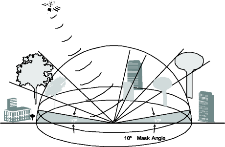
The GPS antenna installation site should be selected such that the maximum aggregate of all blockages above the 10-degree mask angle, such as buildings or mountains, does not exceed 25% of the surface area of a hemisphere around the GPS antenna. This blockage should not be in one contiguous quadrant of the hemisphere. Each contiguously blocked quadrant should be less than 12.5% of the sphere's surface area.
The following diagram shows the mask angle definition for the GPS antenna.
Important! Do not install the GPS antenna directly under structures that may accumulate or shed snow or ice.
It is desirable that the antenna has the clearest view to the south, east, and west in the northern hemisphere and to the north, east, and west in the southern hemisphere.
The following types of obstructions and possible sources of interference need to be considered:
Hills, mountains, trees and surrounding plant life.
Adjacent buildings or any large sky obstructing structures such as grain elevators, airplane hangers, bridges, overhead roadways, etc.
Water towers or any close range large metal objects that could cause excessive sky obstruction.
Any locations where birds or animals may easily nest or build on or around the antenna.
Any co-located RF transmission antennas, TV stations, cable television cables, or arc-welding equipment.
High-voltage lines will not cause interference with GPS signal reception.
Self-supporting or guyed towers will generally not block the GPS signal.
Trees do not totally block but rather degrade GPS reception, especially during periods of heavy rain or snow. Consider if increased summer plant life could also become a problem.
If a GPS antenna is mounted to a monopole antenna mast, it must be mounted a minimum distance (D) from the monopole such that less than 12.5% of a contiguous surface area of a hemisphere around the antenna is blocked by the monopole. The GPS antenna must be spaced a minimum distance D = 1.61 x R (where R is the radius of the monopole at the attachment point of the GPS antenna), from the outside surface of the monopole.
Monopole radius (inches) R = 12
D = (1.61 x 12)
D = 19.3" minimum
This example assumes, of course, that the monopole is the only obstruction to be considered, and constitutes a contiguous 12.5% blockage of the sky. This condition would constitute a contiguous blockage in one quadrant of the hemisphere.
Antenna position can be determined using differential GPS.
Antenna position must be measured with sufficient precision so the center of the circle can be calculated accurately. When just two antennas serve a sector, the center position to be calculated is the average of the position for both antennas.
The position of the center of the circle must be recorded with respect to latitude and longitude, within 0.1 arc-seconds (approximately 3 m) for each.
The altitude of the antenna above the geoid must be specified within 6 m. This is the reference altitude used in GPS, which is specified in WGS 84.
|
|
GO | ||
| © Alcatel-Lucent | |||